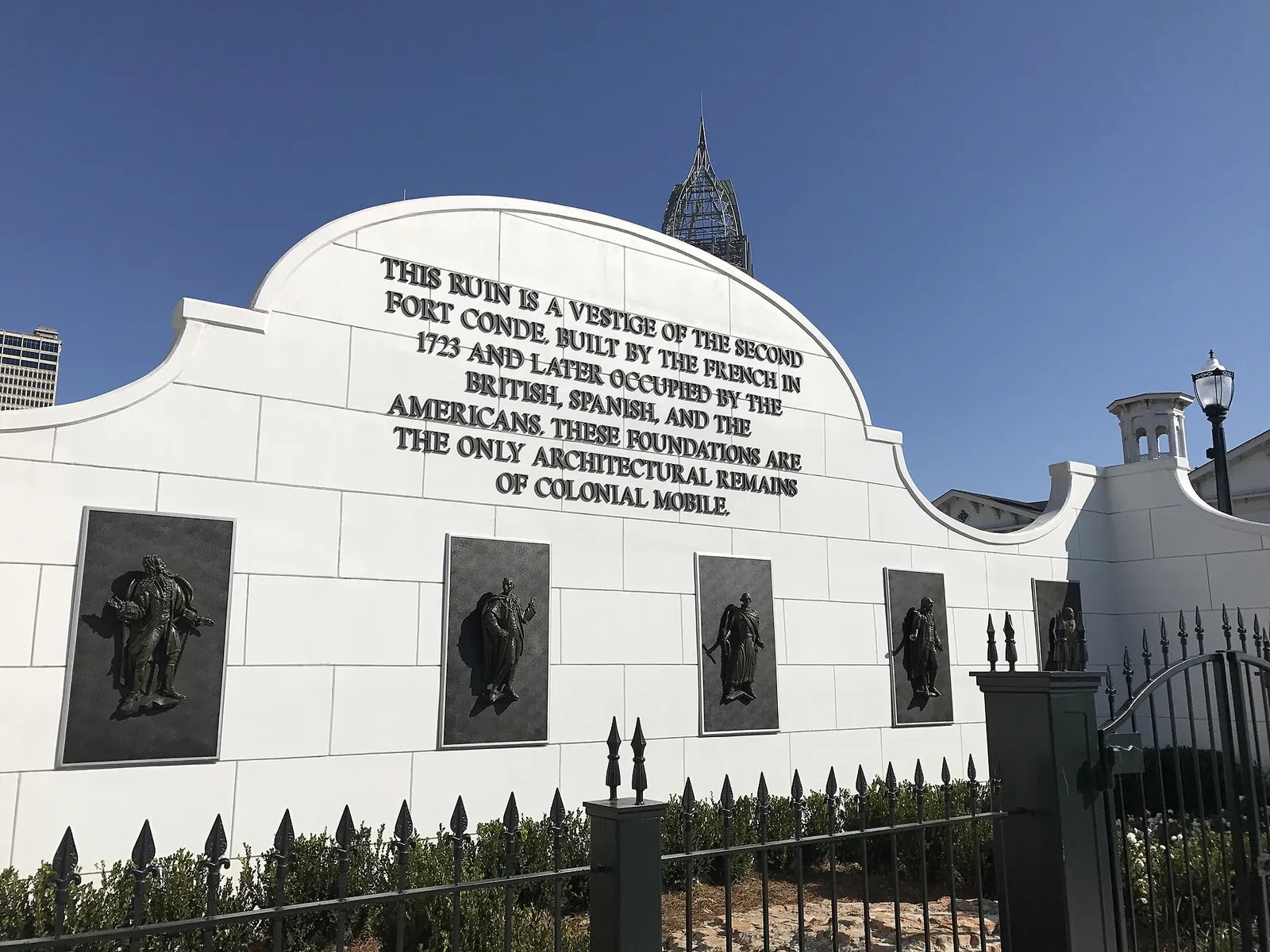
Mobile was settled by the French in 1702 and became American in 1813. It has 126 National Register listings, from Fort Conde to the Africatown Historic District.
Last checked Oct. 17, 2026. Sources: Mobile County’s history of the county, the Encyclopedia of Alabama, the History Museum of Mobile, the Mobile Historic Development Commission and the National Park Service’s National Register of Historic Places data, updated May 22, 2026.
Mobile is one of the oldest cities on the Gulf Coast. Both the city and the county take their name from Fort Louis de la Mobile, the French post built in 1702 near present-day Mount Vernon, according to Mobile County. The county says the name is believed to come from a Choctaw word for “paddlers.”
Who to call
- History Museum of Mobile: 111 S. Royal St., 251-208-7569
- Colonial Fort Conde: 150 S. Royal St., 251-544-5480
- Mobile Historic Development Commission (historic districts, Architectural Review Board): 251-208-7281
Founding and the colonial years
- 1702: Pierre Le Moyne d’Iberville and his brother, Jean-Baptiste Le Moyne de Bienville, settle Mobile up the Mobile River near Twenty-Seven Mile Bluff, according to the Encyclopedia of Alabama. After floods, epidemics and raids damaged the fort, Bienville moved the settlement closer to the mouth of Mobile Bay.
- 1702 to 1763: French rule. Mobile was the capital of French Louisiana until 1720.
- 1723: the French build Fort Conde, according to the History Museum of Mobile.
- 1763 to 1780: British rule; for a short time in the 1760s Mobile was the temporary capital of British West Florida.
- 1780 to 1813: Spanish rule.
- April 13, 1813: the Spanish commandant surrenders his garrison to U.S. Gen. James Wilkinson, and Mobile becomes American. Mobile County had been created on Dec. 18, 1812, by proclamation of the Mississippi Territory’s governor.
- August 1864: Union Adm. David Farragut’s fleet breaks into Mobile Bay. In late May 1865 a waterfront armory explodes, killing 300 workers.
- 1866: Civil War veteran Joseph Stillwell Cain revives Mobile’s Mardi Gras with a parade through the city.
Historic districts
The city has seven local historic districts, where exterior changes need Architectural Review Board approval: Ashland Place, Church Street East, Detonti Square, Leinkauf, Lower Dauphin Street, Oakleigh Garden and Old Dauphin Way, according to the Mobile Historic Development Commission. Federally designated districts also include Africatown, Automobile Alley, Maysville, Oakdale, Lafayette Heights, The Campground and Midtown.
Museums and sites you can visit
| Site | Address | Hours as published |
|---|---|---|
| History Museum of Mobile | 111 S. Royal St., in the National Register-listed Mobile City Hall building | 9 a.m. to 5 p.m. Monday to Saturday, 1 to 5 p.m. Sunday; free the first Sunday of each month |
| Colonial Fort Conde | 150 S. Royal St. | 9 a.m. to 4:30 p.m. Monday to Saturday, 1 to 4:30 p.m. Sunday; included with museum admission |
| Phoenix Fire Museum | 203 S. Claiborne St. | 10 a.m. to 5 p.m. Tuesday to Friday, closed 11:30 a.m. to 12:30 p.m.; free |
| Clotilda: The Exhibition at Africatown Heritage House | Africatown | See the exhibition’s site; tours 251-206-5268 |
| USS Alabama Battleship Memorial Park | 2703 Battleship Parkway | See the park’s site |
| Magnolia Cemetery and Mobile National Cemetery | Ann and Virginia streets | Listed in the city’s park finder at 1202 Virginia St. |
The Clotilda exhibition tells the story of the 110 men, women and children brought from West Africa on the Clotilda and of the community they founded, Africatown.
National Register of Historic Places in Mobile
The National Park Service lists 126 National Register entries with a Mobile address, including four National Historic Landmarks: Mobile City Hall at 111 S. Royal St., now the History Museum, the USS Alabama, the USS Drum and Government Street Presbyterian Church. The table below gives every entry with the year it was listed; boundary changes to a district are listed separately, as the Park Service lists them. Names are as the Park Service records them.
| Property | Address | Type | Listed |
|---|---|---|---|
| Mobile Seamen’s Club Building | 350 St. Joseph St. | Building | Not given |
| Fort Conde-Charlotte | Church and Royal Sts. | Site | 1969 |
| Mobile City Hall | 111 S. Royal St. | Building | 1969 |
| Barton Academy | 504 Government St. | Building | 1970 |
| Mobile City Hospital | 900-950 St. Anthony St. | Building | 1970 |
| Portier, Bishop, House | 307 Conti St. | Building | 1970 |
| Semmes, Raphael, House | 804 Government St. | Building | 1970 |
| Oakleigh | 350 Oakleigh St. | Building | 1971 |
| Horst, Martin, House | 407 Conti St. | Building | 1971 |
| Church Street East Historic District | Roughly bounded by Conti, Water and Claiborne, Eslava, and Warren and Bayou Sts. | District | 1971 |
| De Tonti Square Historic District | Roughly bounded by Adams, St. Anthony, Claiborne, and Conception Sts. | District | 1972 |
| Oakleigh Garden Historic District | Roughly bounded by Government, Marine, Texas, and Ann Sts. | District | 1972 |
| Georgia Cottage | 2564 Springhill Ave. | Building | 1972 |
| Bragg-Mitchell House | 1906 Springhill Ave. | Building | 1972 |
| Carolina Hall | 70 S. McGregor St. | Building | 1973 |
| Brisk & Jacobson Store | 51 Dauphin St. | Building | 1973 |
| Protestant Children’s Home | 911 Dauphin St. | Building | 1973 |
| Spring Hill College Quadrangle | 4307 Old Shell Rd. | Building | 1973 |
| Kirkbride House | 104 Theater St. | Building | 1973 |
| Gates-Daves House | 1570-1572 Dauphin St. | Building | 1974 |
| U.S. Marine Hospital | 800 St. Anthony St. | Building | 1974 |
| Gulf, Mobile, and Ohio Passenger Terminal | Beauregard and St. Joseph Sts. | Building | 1975 |
| Battle House Royale | 26 N. Royal St. | Building | 1975 |
| St. Louis Street Missionary Baptist Church | 108 N. Dearborn St. | Building | 1976 |
| South Lafayette Street Creole Cottages | 20, 22, and 23 S. Lafayette St. | Building | 1976 |
| Fort Gaines | S of Mobile on E end of Dauphin Island | Building | 1976 |
| Pincus Building | 1 S. Royal St. | Building | 1976 |
| Emanuel Building | 100 N. Royal St. | Building | 1978 |
| State Street A.M.E. Zion Church | 502 State St. | Building | 1978 |
| First National Bank | 68 St. Francis St. | Building | 1978 |
| Lower Dauphin Street Historic District | 171 to 614 Dauphin St. | District | 1979 |
| Carlen House | 54 S. Carlen St. | Building | 1981 |
| Tschiener House | 1120 Old Shell Rd. | Building | 1982 |
| Common Street District | 959–1002 Dauphin St. and 7–19 Common St. | District | 1982 |
| Lower Dauphin Street Historic District (Boundary Increase) | Dauphin St. from Water to Dearborn Ave. | District | 1982 |
| Miller-O’Donnell House | 1102 Broad St. | Building | 1982 |
| Cavellero House | 7 N. Jackson St. | Building | 1982 |
| Weems House | 1155 Springhill Ave. | Building | 1982 |
| Coley Building | 56 St. Francis St. | Building | 1982 |
| Murphy High School | 100 S. Carlen St. | Building | 1982 |
| Greene-Marston House | 2000 Dauphin St. | Building | 1983 |
| Davis Avenue Branch, Mobile Public Library | 564 Davis Ave. | Building | 1983 |
| Fire Station No. 5 | 7 N. Lawrence St. | Building | 1983 |
| Vickers and Schumacher Buildings | 707-709 and 711 Dauphin St. | Building | 1983 |
| Dahm House | 7 N. Claiborne St. | Building | 1984 |
| Denby House | 558 Conti St. | Building | 1984 |
| Meaher-Zoghby House | 5 N. Claiborne St. | Building | 1984 |
| Metzger House | 7 N. Hamilton St. | Building | 1984 |
| Monterey Place | 1552 Monterey Pl. | Building | 1984 |
| Neville House | 255 St. Francis St. | Building | 1984 |
| Phillipi House | 53 N. Jackson St. | Building | 1984 |
| Scottish Rites Temple | 351 St. Francis St. | Building | 1984 |
| St. Francis Street Methodist Church | 15 N. Joachim St. | Building | 1984 |
| Church Street East Historic District (Boundary Increase) | Roughly bounded by Broad, Conti, Water, Claiborne, and Canal Sts. | District | 1984 |
| Hawthorn House | 352 Stanton Rd. | Building | 1984 |
| Old Dauphin Way Historic District | Roughly bounded by Springhill Ave., Broad, Government, and Houston Sts. | District | 1984 |
| Beal-Gaillard House | 111 Myrtlewood Lane | Building | 1984 |
| Center-Gaillard House | 3500 The Cedars | Building | 1984 |
| Collins-Marston House | 4703 Old Shell Rd. | Building | 1984 |
| Collins-Robinson House | 56 Oakland Ave. | Building | 1984 |
| Pfau-Creighton Cottage | 3703 Old Shell Rd. | Building | 1984 |
| Saint Paul’s Episcopal Chapel | 4051 Old Shell Rd. | Building | 1984 |
| Sodality Chapel | 4307 Old Shell Rd. | Building | 1984 |
| Stewartfield | 4307 Old Shell Rd. | Building | 1984 |
| Hunter House | 504 St. Francis St. | Building | 1985 |
| Stone Street Baptist Church | 311 Tunstall St. | Building | 1985 |
| USS ALABAMA (battleship) | Battleship Pkwy. | Structure | 1986 |
| USS DRUM (submarine) | Battleship Pkwy. | Structure | 1986 |
| Paterson House | 1673 Government St. | Building | 1986 |
| Magnolia Cemetery including Mobile National Cemetery | Ann and Virginia Sts. | Site | 1986 |
| Emanuel AME Church | 656 Saint Michael St. | Building | 1987 |
| Patton, Dave, House | 1252 Martin Luther King, Jr. Ave. | Building | 1987 |
| Ashland Place Historic District | Roughly bounded by Springhill and Ryan Aves., Old Shell Rd., and Levert Ave. | District | 1987 |
| Leinkauf Historic District | Roughly bounded by Government, S. Monterey, Eslava, Lamar, and S. Monterey Sts. | District | 1987 |
| Azalea Court Apartments | 1820 Old Government St. | Building | 1988 |
| Trinity Episcopal Church | 1900 Dauphin St. | Building | 1990 |
| Lindsey, Martin, House | 3112 Bayfront Rd. | Building | 1991 |
| Oakleigh Garden Historic District (Boundary Increase) | Roughly bounded by Selma St., Broad St., Texas St. and Rapier Ave. | District | 1991 |
| Saint Francis Xavier Roman Catholic Church | 2034 St. Stephens Rd. | Building | 1991 |
| Saint Joseph’s Roman Catholic Church | 808 Springhill Ave. | Building | 1991 |
| Saint Matthew’s Catholic Church | 1200 S. Marine St. | Building | 1991 |
| Stone Street Cemetery | 1700 Martin Luther King, Jr., Blvd. | Site | 1991 |
| Askew, Wade, House | 103 Florence Pl. | Building | 1991 |
| Fearn, George, House | 1806 Airport Blvd. | Building | 1991 |
| Levy, George, House | 107 Florence Pl. | Building | 1991 |
| Megginson, Ernest, House | 143 Florence Pl. | Building | 1991 |
| Morrison, James Arthur, House | 159 Hillwood Rd. | Building | 1991 |
| Paterson, J. E., House | 118 Florence Pl. | Building | 1991 |
| Spotswood, Robert L., House | 1 Country Club Rd. | Building | 1991 |
| VanderSys, Arthur, House | 119 Florence Pl. | Building | 1991 |
| VanderSys, Jacob, House | 129 Florence Pl. | Building | 1991 |
| Walker, Joseph M., House | 104 Florence Pl. | Building | 1991 |
| Convent and Academy of the Visitation | 2300 Springhill Ave. | District | 1992 |
| Convent of Mercy | 753 St. Francis St. | Building | 1992 |
| Saint Vincent de Paul | 351 S. Lawrence St. | Building | 1992 |
| Jossen, Joseph, House | 109 N. Conception St. | Building | 1992 |
| Stewart, Amelia, House | 137 Tuscaloosa St. | Building | 1992 |
| Government Street Presbyterian Church | 300 Government St. | Building | 1992 |
| Cleveland, U. J., House | 551 Charles St. | Building | 1993 |
| Roberts House | 3 Wimbledon Dr. | Building | 1994 |
| Lower Dauphin Street Commercial District (Boundary Increase II) | Roughly, Dauphin St. from Jefferson St. to Dearborn St. and St. Francis St. S side from Bayou St. to Lawrence St. | District | 1995 |
| Lower Dauphin Street Commercial District (Boundary Increase III) | 310 St. Francis St. | District | 1998 |
| Midtown Historic District | Roughly bounded by Taylor Ave., US 90, Houston St., Kenneth St., US 98, and Florida St. | District | 2001 |
| D’Iberville Apartments | 2000 Spring Hill Ave. | Building | 2004 |
| Church Street East Historic District (Boundary Increase II) | 66 and 68 S. Royal St. | District | 2005 |
| Campground, The | Martin Luther King Jr. Ave., Rylands St., St. Stephens Rd. and Ann St. | District | 2005 |
| Aimwell Baptist Church | 500 Earle St. | Building | 2008 |
| Mt. Olive Missionary Baptist Church No.1 | 409 Lexington Ave. | Building | 2008 |
| Turner-Todd Motor Company | 455 St. Louis St. | Building | 2008 |
| United States Court House and Custom House | 113 St. Joseph St. | Building | 2008 |
| Knox, Ross, House | 102 Hillwood Rd. | Building | 2008 |
| Davis Avenue Recreation Center | 1361 Dr. Martin Luther King, Jr. Ave. | Building | 2011 |
| International Longshoreman’s Association Hall | 505 Dr. Martin Luther King, Jr. Ave. | Building | 2011 |
| Caldwell School | 351 Broad St. | Building | 2011 |
| Africatown Historic District | Bounded by Jakes Ln., Paper Mill, & Warren Rds., Chin, & Railroad Sts. | District | 2012 |
| Maysville Historic District | Bounded by Virginia, Ann, Duval & Houston Sts. | District | 2013 |
| Lafayette Heights Historic District | Bounded by Dr. Martin Luther King Jr. & Spring Hill Aves., Rylands & Basil Sts. | District | 2014 |
| Oakdale Historic District | Bounded by I-10, Preston Ave., Virginia & Ann Sts. | District | 2014 |
| Automobile Alley Historic District | 156-157 N. Cedar, 108 N. Dearborn, 100-101 N. Franklin, 156 N. Hamilton, 163 N. Lawrence, 453-701 St. Anthony Sts. | District | 2016 |
| Oakleigh Garden Historic District (Boundary Decrease & Additional Documentation) | Government, Broad, Texas & S. Ann Sts. | District | 2016 |
| Blue Bird Hardware and Seed | 2724 Old Shell Rd. | Building | 2018 |
| Lower Dauphin Street Commercial District | Water, Conti, Broad, St. Francis & St. Louis Sts. | District | 2019 |
| Midtown Historic District (Boundary Increase) | 2401-2403 and 2407 Old Shell Rd. | District | 2020 |
| Old Dauphin Way Historic District (Boundary Increase) | 1200 Springhill Ave. | District | 2022 |
| Automobile Alley Historic District (Boundary Increase) | 752-54, 756, 762 St. Louis St. | District | 2023 |
| Wilmer Hall | 3811 Old Shell Road | District | 2025 |
| ## Related guides |
- Building permits and zoning: historic districts
- Things to do in Mobile this month
- Mobile population and growth
Frequently asked questions
When was Mobile, Alabama founded?
In 1702, when the French brothers Pierre Le Moyne d’Iberville and Jean-Baptiste Le Moyne de Bienville settled Fort Louis de la Mobile up the Mobile River near Twenty-Seven Mile Bluff. The colony later moved closer to the mouth of the bay.
Who ruled Mobile before it was American?
France from 1702 to 1763, Britain from 1763 to 1780 and Spain from 1780 to 1813, according to Mobile County. The Spanish garrison surrendered to U.S. forces on April 13, 1813.
How many National Register sites are in Mobile?
The National Park Service lists 126 National Register of Historic Places entries with a Mobile address, including districts, boundary increases, buildings, sites and the USS Alabama and USS Drum.
What are the historic districts in Mobile?
The city’s local historic districts are Ashland Place, Church Street East, Detonti Square, Leinkauf, Lower Dauphin Street, Oakleigh Garden and Old Dauphin Way. National Register districts also include Africatown, Midtown and others.
Where is Fort Conde in Mobile?
The History Museum of Mobile runs Colonial Fort Conde, a replica opened in 1976, at 150 S. Royal St. Remains of the original 1723 fort, found during construction of the Wallace Tunnel in 1966, are in Mardi Gras Park.
Have your say